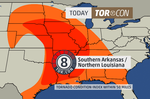
A TORCON of 8 was issued for Southern Arkansas and Northern Louisiana on April 28, 2014. (Image Credit: The Weather Channel on X.com)
While watching The Weather Channel during periods of severe weather, you may have heard meteorologists talking about the TORCON Index for a specific area. What does TORCON mean, and why is it useful? Here is what you need to know about the TORCON Index and how to use it.
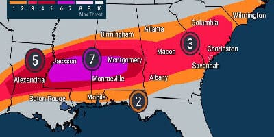
TORCON stands for Tornado Condition Index. On a scale of 0 to 10, a specific region is given a number, with higher numbers indicating a higher risk of a tornado within 50 miles of the given location. For example, a TORCON of 2 would indicate a low chance (20%) of tornadoes, while a TORCON of 8 implies a high probability of tornadic activity (80% chance).
| TORCON | Risk Level | Tornado Probability | What to Do |
|---|---|---|---|
| 0–1 | Minimal | 0–10% chance within 50 miles | No action needed. Monitor standard forecasts. |
| 2–3 | Low | 20–30% chance within 50 miles | Be weather-aware. Know your safe room location. |
| 4–5 | Moderate | 40–50% chance within 50 miles | Monitor weather radio and SPC outlook closely. Have a plan ready. |
| 6–7 | High | 60–70% chance within 50 miles | Stay alert all day. Prepare your safe room and emergency kit. Limit unnecessary travel. |
| 8–9 | Very High | 80–90% chance within 50 miles | Take the day seriously. Have your safe room stocked and accessible. Weather radio on at all times. Avoid unnecessary travel. |
| 10 | Extreme | Near certain tornado activity within 50 miles | Treat as an emergency day. Be in or near your safe room during peak storm hours. Weather radio on constantly. Do not travel unless necessary. |
Who Created the TORCON Index, and Why Is It Useful?
The TORCON Index was created by retired Weather Channel meteorologist Dr. Greg Forbes. A severe weather expert, Dr. Forbes, aimed to simplify how meteorologists communicate severe weather risk to the public with an easy to understand scale.
To see more information on what TORCON is, watch this video narrated by Dr. Forbes himself.
While The Weather Channel has done a few things over the years, which appear to be more of a marketing gimmick than actual science (such as its decision to name winter storms), the TORCON Index has real science behind it.
Dr. Forbes has published several papers on severe weather and worked under Dr. Theodore Fujita—the man that created the Fujita Tornado Scale. His experience there, and in research projects with Penn State University played a large part in his continuing interest in severe weather.
The TORCON index is a combination of three primary factors in severe weather forecasting: instability, wind shear, and “lift.” Below is a brief explanation of what these terms mean.
Instability is the first key ingredient. For thunderstorms to form, air near the surface needs to be able to rise. When warm, moist air sits near the ground with cold, dry air above it, the atmosphere becomes unstable and air parcels near the surface will rise rapidly when given a nudge, fueling the development of deep thunderstorm clouds.
Wind shear is what gives tornadoes their rotation. When wind speed or direction changes with altitude, it creates a horizontal spinning motion in the atmosphere. Strong thunderstorm updrafts can tilt this spinning motion from horizontal to vertical, producing the rotating supercell thunderstorms that are responsible for the majority of significant tornadoes.
Lift is the trigger that sets everything in motion. Even in an unstable atmosphere with strong wind shear, thunderstorms need something to get them started. Lift occurs when air is forced upward along weather fronts, where two air masses meet, or over terrain features. Without sufficient lift, the instability and wind shear may never be realized.
Dr. Forbes’ idea was to take these complex variables and simplify them. The Weather Channel owns the TORCON index’s rights, so the scale isn’t used elsewhere.
Alternatives to TORCON
While there is a scientific basis for Dr. Forbes’ TORCON index, there are other official sources that provide tornado watches and warnings. These alerts are just as accurate to gauge tornado risk and to receive up-to-the-minute severe weather information.
Tornado Watches From the NOAA Storm Prediction Center
The National Weather Service’s Storm Prediction Center issues tornado watches anytime there is a threat for tornadoes to form. While there is no stated equivalency with TORCON, an area where the SPC issues a tornado watch likely has a TORCON of at least 3 or 4. Watch “boxes” can take any shape and are issued on a county-by-county basis over a large area.
To review what a tornado watch means, one is issued when conditions are favorable for a tornado to occur in and near the watch area. When a tornado watch is issued, be prepared by checking forecast updates, knowing where to take shelter, and monitoring sky conditions for tornado warning signs.
Tornado Warnings From the NWS
One thing the TORCON index is not intended for is to warn of the immediate danger of a tornado. That’s the job of tornado warnings issued by the NWS. These are issued for small areas, sometimes even small portions of counties. In this case, a warning means that a funnel cloud tornado has been spotted or radar indicates a high likelihood that a tornado may be on the ground.
Final Thoughts
The TORCON Index is a genuinely useful tool for understanding day-to-day tornado risk, even if its reach is limited to The Weather Channel's forecasts. For the most up-to-date severe weather information, the NOAA Storm Prediction Center is your best resource, and a weather radio is the fastest way to receive official warnings when it matters most. Our best weather radio reviews can help you find a reliable model for your home. You can also explore historical tornado risk by state in our US Interactive Tornado Risk Map, which shows 75 years of NOAA tornado frequency data with state-by-state breakdowns.