The atmosphere does remarkable things everywhere on Earth, but some weather phenomena are so specific to a particular geography, a particular collision of terrain and wind and moisture, that they occur in essentially one place and nowhere else. You cannot see these by checking the right forecast or being in the right state during storm season. You have to go to the specific location where the conditions exist.
These are the weather phenomena so tied to one place that the location and the phenomenon have become inseparable in the scientific literature.
The Morning Glory: Gulf of Carpentaria, Australia
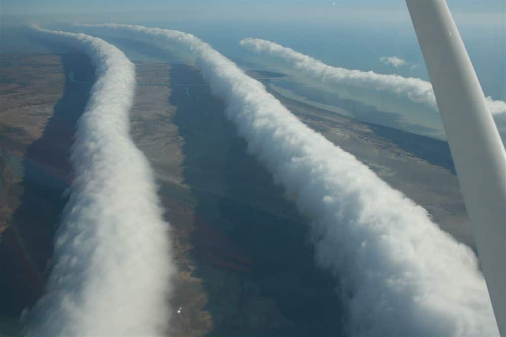
Every spring, a series of enormous rolling tube clouds appears over the remote Gulf of Carpentaria in northern Australia, moving rapidly across the sky like a slow-motion wave breaking in the atmosphere. The Morning Glory cloud can reach lengths of 600 miles, heights of 6,500 feet, and it moves at speeds of 35 to 40 mph while maintaining its distinctive cylindrical shape for hours. It is one of the most visually spectacular atmospheric phenomena on Earth and it occurs with reliable regularity in essentially one place.
The Morning Glory forms from the collision of sea breezes converging from opposite coasts of the Cape York Peninsula, a narrow strip of land that allows marine air to push inland from both the Pacific and the Gulf simultaneously. When these converging air masses meet, they generate an atmospheric bore, a wave that propagates through a shallow layer of cold air near the surface and maintains its structure because of very specific boundary layer conditions that exist reliably only in this part of Australia between September and November.
The small outback town of Burketown, population around 200, has become a minor pilgrimage destination for glider pilots who fly from around the world to ride the powerful updraft on the leading edge of the Morning Glory. The wave produces lift strong enough to allow gliders to travel hundreds of miles without an engine. Experienced local Burketown residents can predict the cloud’s arrival the evening before based on subtle changes in humidity and wind that only someone who has watched the phenomenon for years can detect reliably.
The Everlasting Storm: Lake Maracaibo, Venezuela
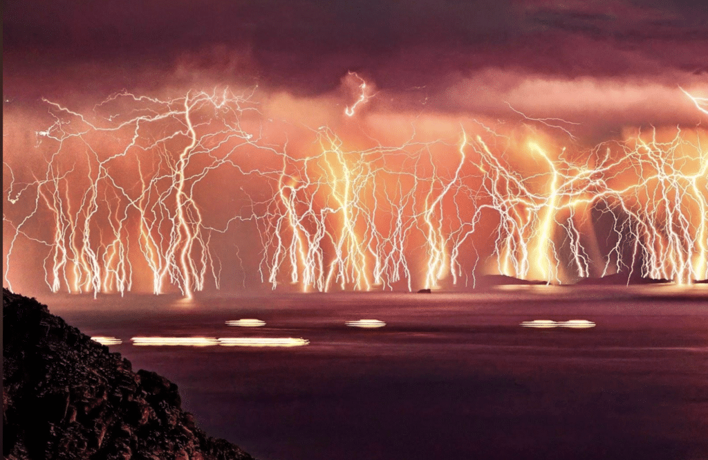
Where the Catatumbo River meets Lake Maracaibo in northwestern Venezuela, lightning strikes up to 280 times per hour for up to 10 hours a night, for up to 300 nights a year. The phenomenon has been occurring so reliably for so long that 16th-century Spanish sailors navigating the Caribbean used it as a lighthouse, calling it the Lighthouse of Maracaibo. It is visible from 250 miles away on a clear night, produces no thunder audible at the lake’s edge, and occurs with such clockwork regularity that locals treat it as simply a feature of the environment rather than a weather event.
The geography of the basin creates conditions that generate thunderstorms with extraordinary reliability. Warm, moist Caribbean air flows inland and is channeled by the surrounding Andes mountains directly toward the lake. As that air rises and cools over the water at night, it reaches the dew point and explodes into thunderstorm development. The surrounding mountains prevent the storms from moving away, so they sit over the lake and discharge lightning continuously for hours until the sun rises and the temperature differential that drives the convection relaxes.
Scientists estimate the Catatumbo lightning generates roughly 1.2 million lightning strikes per year and is responsible for producing more atmospheric ozone than any other single natural source on Earth. A prolonged drought in 2010 stopped the lightning for six weeks, the first documented interruption in recorded history, and prompted widespread alarm among local communities and environmental scientists before the rains returned and the lightning resumed. Venezuela has proposed the Catatumbo lightning for UNESCO World Heritage recognition as a unique natural phenomenon.
The Hole Punch Cloud: Visible globally but formed by a very specific mechanism
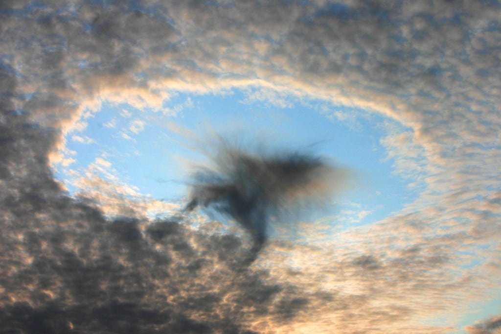
Fallstreak holes, also called hole punch clouds or canal clouds, appear as perfectly circular or elongated gaps punched through a thin layer of altocumulus or cirrocumulus cloud, with wispy ice crystal trails hanging beneath the opening. They look so precisely geometric and so unlike any natural formation that they regularly generate UFO reports when they appear over populated areas, which happens with enough frequency that the National Weather Service keeps a standard explanation ready.
They form when aircraft pass through a layer of supercooled water droplets, water that is below freezing but has not yet frozen because it lacks a nucleus to form ice crystals around. The pressure change from the aircraft’s wings or propellers is enough to trigger the phase change, and once a few droplets start freezing, they trigger a chain reaction that spreads outward from the aircraft’s path. The newly formed ice crystals fall as virga beneath the hole while the surrounding cloud layer, still composed of liquid water droplets, remains intact.
The phenomenon was mysterious for decades because holes would appear in cloud layers far from any airport, with no obvious aircraft in sight. High-altitude military and civilian aircraft flying invisible routes through these cloud layers were eventually identified as the cause. The holes can persist for hours after the aircraft that created them has long since landed. Each fallstreak hole is essentially a permanent record in the sky of an aircraft’s passage through a specific layer of supercooled cloud, readable by anyone who knows what they are looking at.
Fire Whirls: Where wildfire and atmospheric instability combine
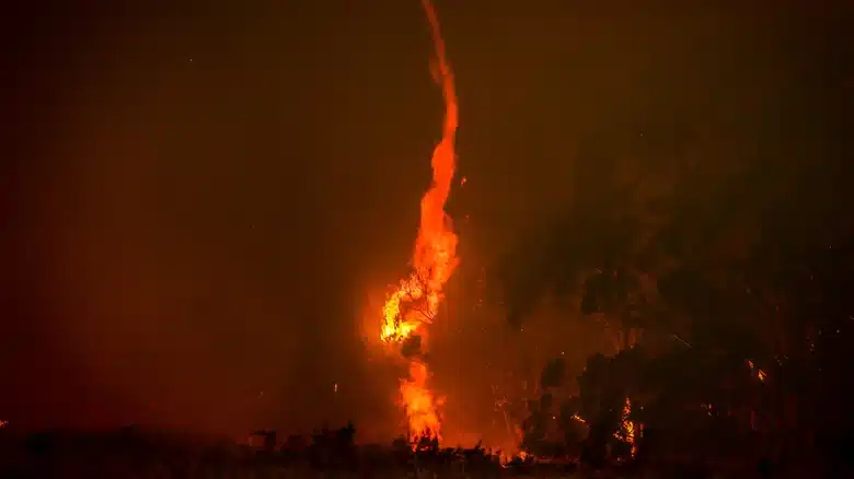
A fire whirl, sometimes called a firenado by news media though the term makes atmospheric scientists visibly uncomfortable, is a rotating column of fire that forms when wildfire-generated heat combines with turbulent winds in a way that produces vorticity, the same spinning motion that creates dust devils, waterspouts, and tornadoes. Unlike those phenomena, fire whirls are composed of actual combusting material and superheated gas, which makes them capable of behaviors that no other weather phenomenon can produce.
Fire whirls range from small, short-lived columns a few feet wide to rare events hundreds of feet tall with wind speeds exceeding 100 mph. The Carr Fire fire whirl in California in 2018 was classified as a fire-generated tornado after analysis of the damage it produced, with estimated wind speeds of 165 mph and a damage path that looked like an EF3 tornado had passed through. It was the first officially classified fire tornado in United States history and destroyed dozens of structures in the community of Redding before dissipating.
The conditions that produce significant fire whirls require a specific combination of intense fire heat generating strong updrafts, ambient wind shear providing the horizontal rotation that the updraft then tilts vertical, and dry, unstable atmospheric conditions that allow the rotating column to sustain itself. Firefighters who have encountered significant fire whirls describe the experience as categorically different from any other fire behavior, capable of overturning vehicles and defeating any containment strategy in seconds. The 1923 Great Kanto Earthquake fire in Tokyo generated fire whirls that killed 38,000 people sheltering in an open park in a single event.
St. Elmo’s Fire: The glow that confused sailors for centuries
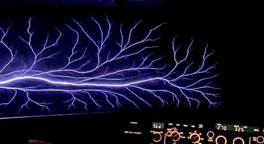
St. Elmo’s Fire is not fire. It is a sustained electrical discharge that occurs when the atmospheric electric field is strong enough to ionize the air around a pointed conductor, such as a ship’s mast, a church steeple, an aircraft’s wingtip, or the horns of cattle in an open field during a thunderstorm. The discharge produces a visible blue or violet glow accompanied by a crackling or hissing sound, and it can persist for minutes at a time. It poses no direct danger to the people or objects it appears on but is an unmistakable sign of extreme electrical conditions in the surrounding atmosphere.
Medieval sailors considered St. Elmo’s Fire a sign of divine protection because its appearance on the rigging after a violent storm seemed to signal that the worst had passed. In reality, the phenomenon appears when the atmospheric charge gradient is steep enough to produce continuous corona discharge at surface points, which can occur both during a developing storm and as conditions begin to improve. The sailors were not entirely wrong in their interpretation: the appearance of St. Elmo’s Fire on the rigging does indicate that the electrical activity in the immediate vicinity has shifted from discrete lightning strikes to continuous lower-level discharge, which often does correspond to a storm’s decreasing intensity.
Modern pilots occasionally report St. Elmo’s Fire on windshields and wingtips during flight through electrified clouds, appearing as a dancing blue glow on the leading edges of the aircraft. The phenomenon has been documented in mountaineering accounts from climbers on high peaks during electrical storms, appearing on ice axes, tent poles, and in rare cases the hair and fingertips of climbers caught in extreme atmospheric conditions at altitude. Each appearance is a reminder that lightning is not the only way a highly charged atmosphere announces itself.
The Fata Morgana: The mirage that sank ships
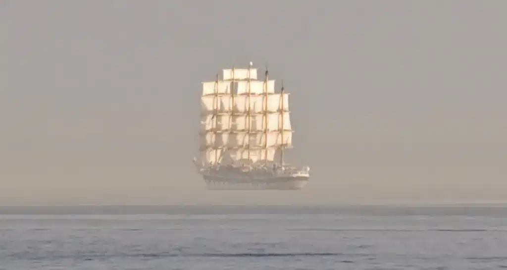
A Fata Morgana is an extreme form of superior mirage that occurs when a layer of warm air sits directly above a layer of very cold air near the surface, bending light in a way that produces highly distorted, stacked, and often completely unrecognizable images of distant objects. Unlike a simple desert mirage that makes pavement look like water, a Fata Morgana can make a distant coastline appear to float above the horizon, stretch a small boat into a towering castle, or make a flat ocean surface look like a range of cliffs. The images can change shape rapidly as atmospheric conditions shift.
The phenomenon is most commonly observed over cold ocean water, particularly in the Arctic, Antarctic, and the northern Pacific and Atlantic. It occurs when cold water cools the air immediately above the surface while the air higher up remains warmer, creating a temperature inversion that acts as a refracting lens. The name comes from the Arthurian sorceress Morgan le Fay, whose magical islands and castles that appeared and disappeared over the water were explained by medieval Italians as her supernatural work. The optical physics were not understood until centuries later.
Maritime historians have proposed that Fata Morgana may have contributed to several famous historical incidents, including Columbus’s records of seeing land before his ships actually reached it and accounts from early Arctic expeditions of coastlines that appeared on the horizon and then vanished. The phenomenon is visible from specific locations with reliable frequency, particularly the Strait of Messina between Italy and Sicily where the temperature conditions between the Tyrrhenian and Ionian Seas create Fata Morgana events that local residents have observed for centuries and that gave the phenomenon its name.