Some weather records are so extreme they sound like someone made them up to win an argument. A temperature drop of 100 degrees in 24 hours. A wind gust measured faster than most commercial aircraft cruise. A hailstone the size of a volleyball. A single lightning storm that has been going almost continuously for thousands of years.
Every single one of these is documented, verified, and completely real. Here are the weather records that genuinely seem impossible until you look at the evidence.
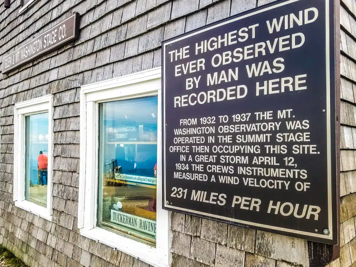
The wind gust faster than a commercial jet: 231 mph, Mount Washington, New Hampshire
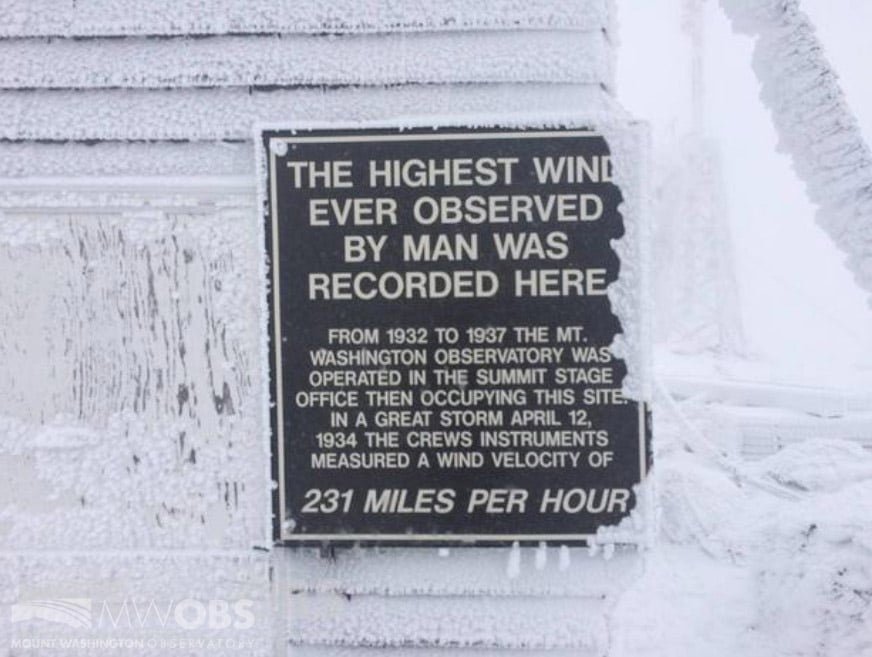
On April 12, 1934, the Mount Washington Observatory recorded a surface wind gust of 231 mph. That is not a typo. Two hundred thirty-one miles per hour, measured at a staffed weather station on the summit of a 6,288-foot mountain in New Hampshire. Commercial aircraft typically cruise at around 550 mph at altitude in calm air. The fastest production cars in the world struggle to reach 280 mph on a closed track. The wind that morning on Mount Washington was doing 231 mph on a rocky summit in April.
The record stood as the absolute world record for the highest wind speed ever recorded at a surface weather station for 76 years until an automated reading from Tropical Cyclone Olivia in Australia measured 253 mph in 1996, a reading that was not officially verified and accepted until 2010. Mount Washington’s record is still the highest directly observed and documented surface wind speed ever recorded by a staffed station.
The summit averages 110 days per year with winds exceeding hurricane force. The observatory has been continuously staffed since 1932 and its employees describe the summit in winter as more similar to Antarctica than New England. The building is bolted to the rock. The bumper sticker that says “This Car Climbed Mt. Washington” exists because the auto road to the summit is genuinely impressive. The weather station at the top is in a completely different category of extreme.
The temperature that dropped 100 degrees in 24 hours: Browning, Montana, 1916
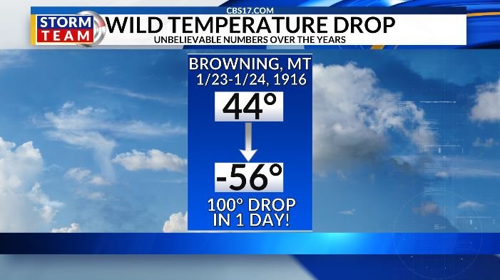
On January 23-24, 1916, the temperature in Browning, Montana dropped from 44°F to -56°F in 24 hours. That is a 100-degree temperature change in one day, a world record for the fastest temperature drop ever documented anywhere on Earth. To put that in terms that make physiological sense: a day that started warm enough to go outside without a heavy coat ended cold enough to cause frostbite on exposed skin in under a minute.
Montana’s position at the intersection of Arctic air masses from Canada and warm Chinook winds from the Pacific creates conditions for extreme temperature swings that no other state can match. Chinook winds can raise temperatures 40 to 50 degrees in a matter of hours as warm Pacific air descends the eastern slopes of the Rockies. When the Chinook shuts off and an Arctic front arrives, the temperature can reverse just as rapidly. Browning, on the Blackfeet Reservation near Glacier National Park, sits in a location where both phenomena occur with unusual frequency.
The 1916 record has never been broken in over a century of global weather observation. The closest challengers have been other Montana locations experiencing the same Chinook-to-Arctic transition pattern that makes the northern Rocky Mountain front one of the most extreme temperature environments on Earth.
The air temperature hotter than a kitchen oven: 134°F, Death Valley, 1913
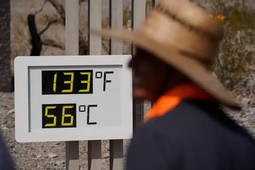
On July 10, 1913, a weather observer at Furnace Creek in Death Valley recorded an air temperature of 134°F. A conventional kitchen oven set to 135°F would cook food, slowly but effectively. Death Valley that day was one degree away from that. The record has stood for over 110 years as the highest air temperature ever reliably measured anywhere on Earth.
Death Valley’s geography makes the record credible even when it sounds absurd. The valley floor sits 282 feet below sea level inside a basin surrounded by mountain ranges that block wind and trap air. The basin floor is dark rock that absorbs solar radiation intensely. Hot air trying to rise is blocked by the mountain walls, compressed, and trapped at the bottom. The valley essentially functions as a natural solar oven with the physics working in every direction to maximize surface temperature simultaneously.
The record was questioned for decades by researchers who suspected the thermometer equipment of the era was not reliable enough to produce an accurate reading at that extreme. A comprehensive review of the historical record published in 2012 upheld the measurement as valid. A temperature of 130°F recorded at Death Valley in August 2020 was the highest temperature reliably measured anywhere in over a century and demonstrated that the valley’s capacity for extreme heat is not a historical artifact.
The hailstone bigger than a soccer ball: 8 inches in diameter, Vivian, South Dakota, 2010

On July 23, 2010, a hailstone measuring 8 inches in diameter and weighing nearly 2 pounds fell in Vivian, South Dakota during a severe thunderstorm. Eight inches in diameter means roughly the size of a large cantaloupe, or a bit larger than a softball. It is the largest hailstone ever officially measured in the United States and one of the largest ever documented anywhere in the world. The stone had to be kept in a freezer and transported carefully to be measured and verified by the National Weather Service.
Hail forms when water droplets are carried repeatedly upward into freezing regions of a thunderstorm’s updraft, adding layers of ice with each cycle. Violent supercell thunderstorms with exceptionally powerful updrafts can suspend hailstones aloft long enough to grow them to extraordinary sizes. The updraft speed required to keep an 8-inch, 2-pound stone airborne is somewhere around 170 mph, which gives a sense of the energy inside the thunderstorm that produced Vivian’s record stone.
The previous record holder, a 7-inch stone that fell in Aurora, Nebraska in 2003, was itself a record that had stood for only seven years. Large hail events in the central plains are frequent enough that the record gets challenged periodically, and the Vivian stone has held for over a decade now as evidence of what South Dakota thunderstorms are capable of producing.
The lightning storm that never stops: Lake Maracaibo, Venezuela

There is a place on Earth where lightning strikes up to 280 times per hour, for up to 10 hours per night, for up to 300 nights per year. Lake Maracaibo in northwestern Venezuela holds the world record for the most lightning strikes per square kilometer per year, and the phenomenon has been occurring so consistently for so long that 16th-century sailors used it as a navigation beacon. They called it the Lighthouse of Maracaibo. It is still sometimes called the Everlasting Storm.
The Catatumbo lightning, named for a river that empties into Lake Maracaibo, is driven by geography that functions as a near-perfect lightning generator. Warm, moist Caribbean air flows inland and collides with the cool air descending from the surrounding Andes mountains. The topography channels this collision directly over the lake almost every night during the rainy season, producing thunderstorm development so reliable that locals can set their watches by it. The lightning occurs most frequently between midnight and 3 a.m. and is visible from 250 miles away on a clear night.
A severe drought in 2010 temporarily stopped the lightning for six weeks, the first time in recorded history that the storm had fully stopped for an extended period. The interruption prompted the Venezuelan government to consider applying for UNESCO World Heritage status for the phenomenon. The lightning returned with the rains. The Catatumbo lightning has struck Lake Maracaibo more times than any other location on Earth has ever been struck in recorded history, and it shows no signs of stopping.
The single snowstorm that dropped 75 inches: Thompson Pass, Alaska, 1955
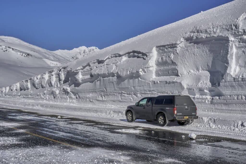
Between December 26 and 31, 1955, Thompson Pass in Alaska received 175.4 inches of snow in a single month, the highest monthly snowfall total ever recorded in the United States. Within that same period, a single storm dropped 62 inches in 24 hours, the highest single-day snowfall total ever recorded in Alaska. Thompson Pass sits in the Chugach Mountains northeast of Valdez and funnels moisture-laden Gulf of Alaska air upward in a geography that essentially maximizes orographic snowfall every time a storm arrives from the south.
The pass averages over 550 inches of snow per year, making it one of the snowiest inhabited locations on Earth. The highway that passes through it, the Richardson Highway connecting Valdez to the interior, requires avalanche control operations throughout winter that include artillery used to trigger controlled slides before they become uncontrolled ones. The road stays open year-round primarily because Valdez is a major oil terminal, and keeping the access route clear is an economic necessity rather than a convenience.
For comparison, Buffalo, New York, which holds the popular American imagination as the snowiest city in the lower 48, averages roughly 90 inches of snow per year. Thompson Pass averages more snow in a single above-average month than Buffalo receives in an entire year.
The wave that reached 1,720 feet: Lituya Bay, Alaska, 1958
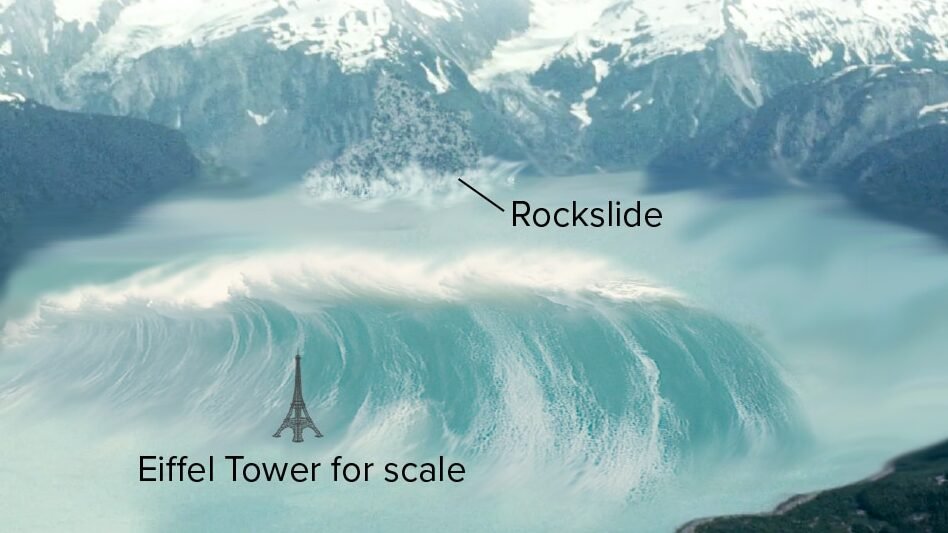
On July 9, 1958, an earthquake triggered a massive rockslide into the narrow inlet of Lituya Bay on Alaska’s southeast coast. The rockslide displaced enough water to generate a wave that ran up the opposite mountainside to a height of 1,720 feet, stripping all trees and vegetation from the slope in a swathe visible from miles away. It remains the tallest wave ever recorded in human history and was witnessed by fishermen in the bay who described what they saw as an incomprehensible wall of water moving faster than anything they had ever seen.
Three fishing boats were anchored in the bay when the wave struck. One boat was lifted up and carried over the spit at the bay’s entrance, depositing the crew safely on the other side in an event they found so unbelievable that their account was initially dismissed before the physical evidence on the mountainside confirmed the wave height. The crew of a second boat was killed when their vessel sank in the chaos. A third boat also sank with its crew lost.
The 1,720-foot wave at Lituya Bay was not caused by weather in the conventional sense, but it was triggered by an earthquake in a region where the combination of glacial terrain, steep fjord walls, and seismic activity creates conditions that can produce waves no ocean storm could generate. The incident is included in discussions of extreme natural water events as the benchmark for wave height that has never been approached by any storm-generated wave in recorded history.